IMAGES TAKEN NEAR TO
Crown Road, SEVENOAKS, TN14 7TW
Introduction
This page details the photographs taken nearby to Crown Road, TN14 7TW by members of the Geograph project.
The Geograph project started in 2005 with the aim of publishing, organising and preserving representative images for every square kilometre of Great Britain, Ireland and the Isle of Man.

There are currently over 7.5m images from over14,400 individuals and you can help contribute to the project by visiting https://www.geograph.org.uk
Image Map
Images are licensed for reuse under creativecommons.org/licenses/by-sa/2.0
Notes
- Clicking on the map will re-center to the selected point.
- The higher the marker number, the further away the image location is from the centre of the postcode.
Image Listing (112 Images Found)
Images are licensed for reuse under creativecommons.org/licenses/by-sa/2.0
Image
Details
Distance
1
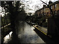
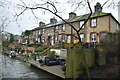
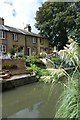
Cottages next to the River Darent
The Darent Valley Path is 19 miles long and follows the River Darent from the Thames near Dartford to the Greensand Hills above Sevenoaks. Dating from 1869, these cottages are at the northern end of Shoreham on the way to Lullingstone. They were for workers at Lower (Shoreham Paper) Mill, which was just below here - see http://www.geograph.org.uk/photo/3865601
The Darent Valley Path crosses the river just ahead. See http://en.wikipedia.org/wiki/Darent_Valley_Path and http://www.kent.gov.uk/leisure_and_culture/countryside_and_coast/walking/darent_valley_path.aspx for more information about the Darent Valley Path.
Image: © Marathon
Taken: 21 Feb 2014
0.00 miles
2
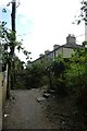
Cottages in Shoreham
The Darent Valley path crosses the river on the left.
Image: © DS Pugh
Taken: 10 Jul 2023
0.00 miles
3
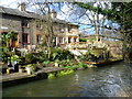
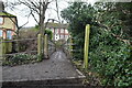
Houses from the bridge
Looking along the Darent from a footbridge at some riverside properties.
Image: © DS Pugh
Taken: 18 Aug 2019
0.00 miles
6
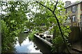
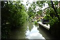
River Darent in Shoreham
Looking upstream from a footbridge.
Image: © DS Pugh
Taken: 10 Jul 2023
0.01 miles
7
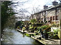
Cottages next to the River Darent
The Darent Valley Path is 19 miles long and follows the River Darent from the Thames near Dartford to the Greensand Hills above Sevenoaks. Dating from 1869, these cottages are at the northern end of Shoreham on the way from Lullingstone. They were for workers at Lower (Shoreham Paper) Mill, which was just below here - see http://www.geograph.org.uk/photo/3865601
See http://en.wikipedia.org/wiki/Darent_Valley_Path and http://www.kent.gov.uk/leisure_and_culture/countryside_and_coast/walking/darent_valley_path.aspx for more information about the Darent Valley Path.
Image: © Marathon
Taken: 21 Feb 2014
0.01 miles
8
Houses on the Darent
Some riverside properties north of Shoreham.
Image: © DS Pugh
Taken: 18 Aug 2019
0.01 miles
9
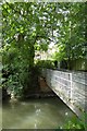
Bridge over the Darent
Looking across a bridge over the River Darent.
Image: © DS Pugh
Taken: 18 Aug 2019
0.01 miles