IMAGES TAKEN NEAR TO
Station Road, SEVENOAKS, TN14 7SA
Introduction
This page details the photographs taken nearby to Station Road, TN14 7SA by members of the Geograph project.
The Geograph project started in 2005 with the aim of publishing, organising and preserving representative images for every square kilometre of Great Britain, Ireland and the Isle of Man.

There are currently over 7.5m images from over14,400 individuals and you can help contribute to the project by visiting https://www.geograph.org.uk
Image Map (Loading...)


Getting Data...Please wait
Leaflet Map data © OpenStreetMap
Images are licensed for reuse under creativecommons.org/licenses/by-sa/2.0
Notes
- Clicking on the map will re-center to the selected point.
- The higher the marker number, the further away the image location is from the centre of the postcode.
Image Listing (92 Images Found)
Images are licensed for reuse under creativecommons.org/licenses/by-sa/2.0
Image
Details
Distance
1
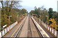
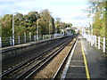
Shoreham Station
Shoreham Station, Kent. Looking "down" toward Otford. The line carries South-Eastern Blackfriars to Sevenoaks, and Victoria to Ashford via Maidstone East services.
Image: © Edward
Taken: 31 Oct 2004
0.01 miles
3
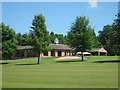
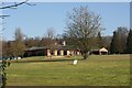
Darent Golf Clubhouse
This golf clubhouse is on Station Road in Shoreham. It is seen from the Darent Valley Path (long distance path), which leads through the golf course to Otford.
Image: © David Anstiss
Taken: 30 May 2009
0.02 miles
4
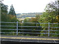
View across the Darent Valley from Shoreham station
The Swanley to Sevenoaks Bat & Ball line was opened on 2nd June 1862 by the London, Chatham & Dover Railway Company. Electric services between Bickley and Sevenoaks were introduced on 6th January 1935. After leaving Swanley and passing through a tunnel to reach the Darent Valley the line crosses Eynsford Viaduct and then follows the east side of the valley.
Image: © Marathon
Taken: 30 Oct 2012
0.04 miles
5
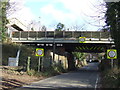
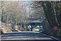
Low bridge, Shoreham
The railway bridge across Station Road in Shoreham. The height of the bridge means that vehicles more than 13 feet high are prohibited from passing.
The footbridge in the top left of the image links the two platforms at Shoreham railway station. The station platforms have been extended so that they now span the road. The steel girder structure in front of the main bridge carries one of the platforms.
Image: © Malc McDonald
Taken: 15 Jan 2012
0.05 miles
6
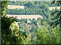
Shoreham Village, Kent
View from Meenfield Wood, to the west of the village.
Image: © Philip Talmage
Taken: 15 Sep 2003
0.05 miles
8
Shoreham station
The Swanley to Sevenoaks Bat & Ball line was opened on 2nd June 1862 by the London, Chatham & Dover Railway Company. Electric services between Bickley and Sevenoaks were introduced on 6th January 1935. Just this side of the footbridge is the bridge over Shoreham Road which leads from the A225 to the village of Shoreham. Trains to and from Sevenoaks stop here. Trains to and from Maidstone East and Ashford International do not stop between Swanley and Otford.
Image: © Marathon
Taken: 30 Oct 2012
0.05 miles
10
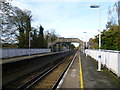
Shoreham station
The Swanley to Sevenoaks Bat & Ball line was opened on 2nd June 1862 by the London, Chatham & Dover Railway Company. Electric services between Bickley and Sevenoaks were introduced on 6th January 1935. Just this side of the footbridge is the bridge over Shoreham Road which leads from the A225 to the village of Shoreham. Trains to and from Sevenoaks stop here. Trains to and from Maidstone East and Ashford International do not stop between Swanley and Otford. The old footbridge seen here has recently been replaced by a new one.
Image: © Marathon
Taken: 30 Oct 2012
0.06 miles