IMAGES TAKEN NEAR TO
Wheatsheaf Hill, SEVENOAKS, TN14 7DX
Introduction
This page details the photographs taken nearby to Wheatsheaf Hill, TN14 7DX by members of the Geograph project.
The Geograph project started in 2005 with the aim of publishing, organising and preserving representative images for every square kilometre of Great Britain, Ireland and the Isle of Man.

There are currently over 7.5m images from over14,400 individuals and you can help contribute to the project by visiting https://www.geograph.org.uk
Image Map
Images are licensed for reuse under creativecommons.org/licenses/by-sa/2.0
Notes
- Clicking on the map will re-center to the selected point.
- The higher the marker number, the further away the image location is from the centre of the postcode.
Image Listing (45 Images Found)
Images are licensed for reuse under creativecommons.org/licenses/by-sa/2.0
Image
Details
Distance
1
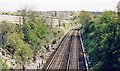
Main line to Tonbridge, Ashford and Dover from near Knockholt
View SE, towards Sevenoaks, Tonbridge etc.: ex-SE&CR London - Sevenoaks - Tonbridge - Ashford - Dover main line, electrified to Sevenoaks, electrified to Sevenoaks 1/35, beyond in 7/61. Knockholt station is about 500 yards behind here.
Image: © Ben Brooksbank
Taken: 22 Apr 1997
0.04 miles
5
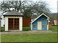
Buildings for gardens
Two of a large number of buildings of many types on display here.
Image: © Robin Webster
Taken: 14 Feb 2012
0.08 miles