IMAGES TAKEN NEAR TO
Hubbards Hill, SEVENOAKS, TN14 6LS
Introduction
This page details the photographs taken nearby to Hubbards Hill, TN14 6LS by members of the Geograph project.
The Geograph project started in 2005 with the aim of publishing, organising and preserving representative images for every square kilometre of Great Britain, Ireland and the Isle of Man.

There are currently over 7.5m images from over14,400 individuals and you can help contribute to the project by visiting https://www.geograph.org.uk
Image Map
Images are licensed for reuse under creativecommons.org/licenses/by-sa/2.0
Notes
- Clicking on the map will re-center to the selected point.
- The higher the marker number, the further away the image location is from the centre of the postcode.
Image Listing (49 Images Found)
Images are licensed for reuse under creativecommons.org/licenses/by-sa/2.0
Image
Details
Distance
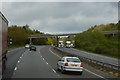
2
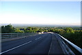
View south from Hubbards Hill
This is the bridge over the A21
Image: © N Chadwick
Taken: 1 Jul 2009
0.02 miles
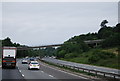
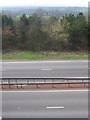
3
Hubbard's Hill Bridge over the A21
The A21 descends the Greensand escarpment.
Image: © N Chadwick
Taken: 2 Jul 2010
0.02 miles
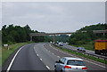
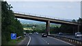
5
A21 viewed from the road bridge at Hubbard's Hill
On a clear day, great views of the Sevenoaks Weald can be seen from the vantage point of Hubbard's Hill.
Image: © Nikki Mahadevan
Taken: 16 Apr 2006
0.02 miles
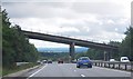
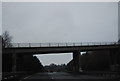
7
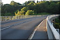
Hubbard's Hill Bridge
Hubbard's Hill crosses the A21
Image: © N Chadwick
Taken: 1 Jul 2009
0.03 miles