IMAGES TAKEN NEAR TO
Winkhurst Green, SEVENOAKS, TN14 6LE
Introduction
This page details the photographs taken nearby to Winkhurst Green, TN14 6LE by members of the Geograph project.
The Geograph project started in 2005 with the aim of publishing, organising and preserving representative images for every square kilometre of Great Britain, Ireland and the Isle of Man.

There are currently over 7.5m images from over14,400 individuals and you can help contribute to the project by visiting https://www.geograph.org.uk
Image Map
Images are licensed for reuse under creativecommons.org/licenses/by-sa/2.0
Notes
- Clicking on the map will re-center to the selected point.
- The higher the marker number, the further away the image location is from the centre of the postcode.
Image Listing (10 Images Found)
Images are licensed for reuse under creativecommons.org/licenses/by-sa/2.0
Image
Details
Distance
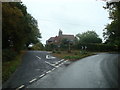
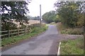
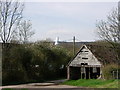
2
Road junction with cottage north of Winkhurst Green
See http://www.geograph.org.uk/photo/1553351 for an almost identical picture from 2009.
The Royal Mail box on the left has nearly fallen over completely.
Image: © Shazz
Taken: 30 Jul 2016
0.06 miles
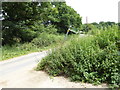
3
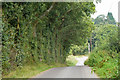
Lane towards Scallops Farm
This lane has no mapped or signed name.
Image: © Robin Webster
Taken: 19 Aug 2011
0.09 miles
4
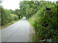
Looking east on minor road going east from Ide Hill Road
Image: © Shazz
Taken: 30 Jul 2016
0.11 miles
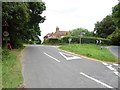
5
Scollops Farm Road
This road leads from the farm towards the B2042 Ide Hill Road.
Image: © David Anstiss
Taken: 11 Oct 2009
0.16 miles
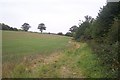
6
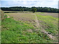
Footpath to Scollops Farm
This footpath descends from the wooded Greensand Ridge at Stubbs Wood to meet a lane at Scollops Farm ahead.
Image: © Marathon
Taken: 21 Sep 2014
0.17 miles
7
Footpath junction with minor road west of Scollops Farm
Image: © Shazz
Taken: 30 Jul 2016
0.19 miles
8
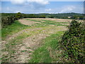
Footpath to the Greensand Ridge
This footpath beyond Scollops Farm steadily rises to the wooded Greensand Ridge ahead at Boarhill and Stubbs Wood.
Image: © Marathon
Taken: 21 Sep 2014
0.22 miles
9
Old Wagon Lodge & Scollops Oast House
These buildings are situated at the bottom of York's Hill, near Ide Hill village. This is an extremely steep narrow road where every October cyclists gather for a gruelling uphill ride.
Image: © Jean Barrow
Taken: 22 Apr 2006
0.24 miles
10
Footpath to Winkhurst Green
This path leads from Scollops Farm towards Bough Beech Reservoir. The path follows the side of a stream to the reservoir.
Image: © David Anstiss
Taken: 11 Oct 2009
0.24 miles