IMAGES TAKEN NEAR TO
Sundridge Road, SEVENOAKS, TN14 6JP
Introduction
This page details the photographs taken nearby to Sundridge Road, TN14 6JP by members of the Geograph project.
The Geograph project started in 2005 with the aim of publishing, organising and preserving representative images for every square kilometre of Great Britain, Ireland and the Isle of Man.

There are currently over 7.5m images from over14,400 individuals and you can help contribute to the project by visiting https://www.geograph.org.uk
Image Map
Images are licensed for reuse under creativecommons.org/licenses/by-sa/2.0
Notes
- Clicking on the map will re-center to the selected point.
- The higher the marker number, the further away the image location is from the centre of the postcode.
Image Listing (185 Images Found)
Images are licensed for reuse under creativecommons.org/licenses/by-sa/2.0
Image
Details
Distance
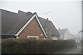
6
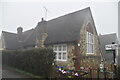
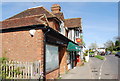
Ide Hill Primary School
Grade II listed.
Image: © N Chadwick
Taken: 27 Jan 2021
0.03 miles
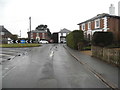
7
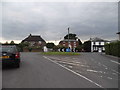
Roundabout in Ide Hill
New Road is on the other side but not certain if it's this side as well.
Image: © David Howard
Taken: 17 Aug 2015
0.03 miles
8
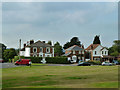
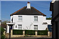
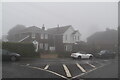
Houses by village green, Ide Hill
The roundabout in front of the house on the left appears to be merely to get traffic round the right-angled bend safely and slowly. The joining road here is a dead-end with very little traffic.
Image: © Robin Webster
Taken: 19 Aug 2011
0.03 miles
9
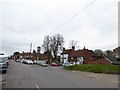
Ide Hill village centre
On Camberwell Lane
Image: © David Howard
Taken: 15 Mar 2015
0.03 miles