IMAGES TAKEN NEAR TO
Chapmans Road, SEVENOAKS, TN14 6DR
Introduction
This page details the photographs taken nearby to Chapmans Road, TN14 6DR by members of the Geograph project.
The Geograph project started in 2005 with the aim of publishing, organising and preserving representative images for every square kilometre of Great Britain, Ireland and the Isle of Man.

There are currently over 7.5m images from over14,400 individuals and you can help contribute to the project by visiting https://www.geograph.org.uk
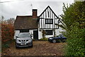
Image Map
Images are licensed for reuse under creativecommons.org/licenses/by-sa/2.0
Notes
- Clicking on the map will re-center to the selected point.
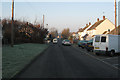
- The higher the marker number, the further away the image location is from the centre of the postcode.
Image Listing (69 Images Found)
Images are licensed for reuse under creativecommons.org/licenses/by-sa/2.0
Image
Details
Distance
3
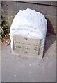
Old Milestone by the A25, Main Road, Sundridge parish
Metal plate attached to stone post by the A25, in parish of SUNDRIDGE (SEVENOAKS District), Main Road, by No. 134, "Milestone", West of Social Club, in pavement, back to garden wall, on North side of road. Wrotham iron plate, erected by the Wrotham Heath turnpike trust in the 19th century.
Inscription reads:-
MAIDSTONE 19
GODSTONE 9½
Kent HER.
HER Number: TQ 45 NE 185 https://www.heritagegateway.org.uk/Gateway/Results_Single.aspx?uid=MKE78088&resourceID=1005
Milestone Society National ID: KE_MDGS19.
Image: © C Woodward
Taken: 30 Apr 2007
0.08 miles
4
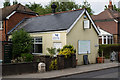
Main Road
On the left is the convenience store and post office for Sundridge.
Image: © Ian Capper
Taken: 20 Jun 2013
0.08 miles
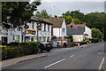
5
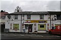
Sundridge and Brasted Social Club
Social club on Main Road, Sundridge. Note the damaged milestone, a reminder that before the building of the M25, the A25 was a major east-west route dating from the 1760s as the Wrotham Heath and Croydon and Godstone Road Turnpike. Compare Image, the next one to the west, with metal plate still intact.
Image: © Ian Capper
Taken: 20 Jun 2013
0.08 miles
6
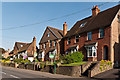
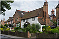
Main Road
A row of houses on Main Road. The weatherboarded cottage towards the left of the photo dates from at least the 17th century and is grade II listed - see www.historicengland.org.uk/listing/the-list/list-entry/1243964.
Image: © Ian Capper
Taken: 28 Jun 2012
0.08 miles
8
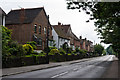
Main Road
The A25 through Sundridge. The plaque on the house on the left, North View, gives a building date of 1914. The house beyond is much older, dating from the 17th century or earlier (see Image for close up).
Image: © Ian Capper
Taken: 20 Jun 2013
0.09 miles
9
135/137 Main Road
17th century or early grade II listed cottage on Main Road - see www.historicengland.org.uk/listing/the-list/list-entry/1243964.
Image: © Ian Capper
Taken: 20 Jun 2013
0.09 miles
10
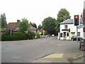
Cross roads on the A25 at Sundridge
A familiar view for those driving along the A25 towards Sevenoaks
Image: © Nigel Freeman
Taken: 9 Jul 2005
0.10 miles