IMAGES TAKEN NEAR TO
Church Road, SEVENOAKS, TN14 6AT
Introduction
This page details the photographs taken nearby to Church Road, TN14 6AT by members of the Geograph project.
The Geograph project started in 2005 with the aim of publishing, organising and preserving representative images for every square kilometre of Great Britain, Ireland and the Isle of Man.

There are currently over 7.5m images from over14,400 individuals and you can help contribute to the project by visiting https://www.geograph.org.uk
Image Map (Loading...)


Getting Data...Please wait
Leaflet Map data © OpenStreetMap
Images are licensed for reuse under creativecommons.org/licenses/by-sa/2.0
Notes
- Clicking on the map will re-center to the selected point.
- The higher the marker number, the further away the image location is from the centre of the postcode.
Image Listing (7 Images Found)
Images are licensed for reuse under creativecommons.org/licenses/by-sa/2.0
Image
Details
Distance
1
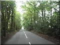
Birchfield Farmland
This photograph was taken from New Road that runs from Ide Hill to Brasted and is looking across towards Sundridge.
Image: © Jean Barrow
Taken: 1 May 2006
0.17 miles
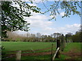
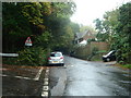
2
Access road to Sundridge Place Farm
Seen from Church Road. This is also a bridleway, through the farm to Dryhill Farm.
Image: © David Anstiss
Taken: 17 Jan 2010
0.17 miles
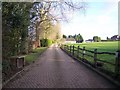
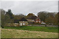
3
Barn, Sundridge Place
Grade II listed. https://historicengland.org.uk/listing/the-list/list-entry/1272722
Image: © N Chadwick
Taken: 22 Nov 2019
0.21 miles
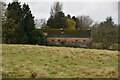
5
Sundridge Place
Grade II listed. https://historicengland.org.uk/listing/the-list/list-entry/1243895
Image: © N Chadwick
Taken: 22 Nov 2019
0.23 miles
6
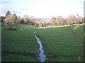
Stream near Sundridge Place Farm
Seen from a bridleway from Church Road to Dryhill Farm on Dryhill Lane.
The North Downs are in the background.
Image: © David Anstiss
Taken: 17 Jan 2010
0.23 miles