IMAGES TAKEN NEAR TO
Combe Bank Drive, SEVENOAKS, TN14 6AE
Introduction
This page details the photographs taken nearby to Combe Bank Drive, TN14 6AE by members of the Geograph project.
The Geograph project started in 2005 with the aim of publishing, organising and preserving representative images for every square kilometre of Great Britain, Ireland and the Isle of Man.

There are currently over 7.5m images from over14,400 individuals and you can help contribute to the project by visiting https://www.geograph.org.uk
Image Map
Images are licensed for reuse under creativecommons.org/licenses/by-sa/2.0
Notes
- Clicking on the map will re-center to the selected point.
- The higher the marker number, the further away the image location is from the centre of the postcode.
Image Listing (7 Images Found)
Images are licensed for reuse under creativecommons.org/licenses/by-sa/2.0
Image
Details
Distance
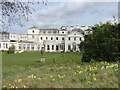
1
Zebra crossing outside Combe Bank school
Image: © David Howard
Taken: 20 Apr 2014
0.02 miles
3
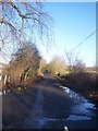
Combe Bank Drive
Combe Bank Drive leads of Chevening Road in Sundridge to Combe Bank School. Then it becomes a byway track towards Ovenden Road.
Image: © David Anstiss
Taken: 17 Jan 2010
0.06 miles
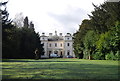
4
Combe Bank School, Sundridge
Combe Bank is a fine Palladian house built in 1720. The buildings are now used as an independent girls school. Details of the school and estate can be found at: http://www.combebank.kent.sch.uk
Image: © Pete Chapman
Taken: Unknown
0.10 miles
5

Dibgate Farm, Sundridge
Artists Studios
Image: © Richard Rogerson
Taken: 8 Jun 2014
0.23 miles
6
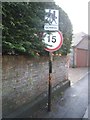
Pre-Worboys school sign on Combe Bank Drive
Besides the addition of a modern 15mph sign everything is exactly as it was when it was put up. There is no bracket above so there was no triangle where it would usually be.
Image: © David Howard
Taken: 20 Apr 2014
0.25 miles
7
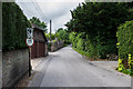
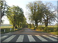
Combe Bank Drive
Leading to Combe Bank School. For close up of the school sign on the left, see Image
Image: © Ian Capper
Taken: 21 Jun 2013
0.25 miles