IMAGES TAKEN NEAR TO
Vestry Road, SEVENOAKS, TN14 5EL
Introduction
This page details the photographs taken nearby to Vestry Road, TN14 5EL by members of the Geograph project.
The Geograph project started in 2005 with the aim of publishing, organising and preserving representative images for every square kilometre of Great Britain, Ireland and the Isle of Man.

There are currently over 7.5m images from over14,400 individuals and you can help contribute to the project by visiting https://www.geograph.org.uk
Image Map
Images are licensed for reuse under creativecommons.org/licenses/by-sa/2.0
Notes
- Clicking on the map will re-center to the selected point.
- The higher the marker number, the further away the image location is from the centre of the postcode.
Image Listing (23 Images Found)
Images are licensed for reuse under creativecommons.org/licenses/by-sa/2.0
Image
Details
Distance
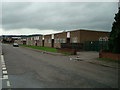
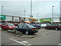
1

Your Mini Adventure Starts Here
On an industrial estate, Sevenoaks.
Image: © Robin Webster
Taken: 28 Jan 2007
0.01 miles


10
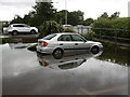
Flash flood at Otford
At about 5pm on Saturday 25th June 2016 the most intense rainfall I have ever seen took place at Otford. It lasted about half an hour with thunderstorms and intense hail. People were marooned inside stores in Riverside Retail Park while it lasted and when it finished some found they could not reach their cars.
Image: © Marathon
Taken: 25 Jun 2016
0.14 miles