IMAGES TAKEN NEAR TO
Mount Harry Road, SEVENOAKS, TN13 3GW
Introduction
This page details the photographs taken nearby to Mount Harry Road, TN13 3GW by members of the Geograph project.
The Geograph project started in 2005 with the aim of publishing, organising and preserving representative images for every square kilometre of Great Britain, Ireland and the Isle of Man.

There are currently over 7.5m images from over14,400 individuals and you can help contribute to the project by visiting https://www.geograph.org.uk
Image Map (Loading...)


Getting Data...Please wait
Leaflet Map data © OpenStreetMap
Images are licensed for reuse under creativecommons.org/licenses/by-sa/2.0
Notes
- Clicking on the map will re-center to the selected point.
- The higher the marker number, the further away the image location is from the centre of the postcode.
Image Listing (89 Images Found)
Images are licensed for reuse under creativecommons.org/licenses/by-sa/2.0
Image
Details
Distance
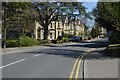
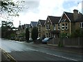
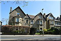
2
Mount Harry Road
Looking down Mount Harry Road near the A225.
Image: © DS Pugh
Taken: 21 Aug 2019
0.03 miles
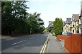
6
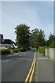
Along Mount Harry Road
Looking along the road leading towards Sevenoaks Station.
Image: © DS Pugh
Taken: 21 Aug 2019
0.07 miles
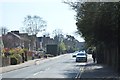
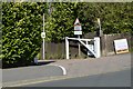
10
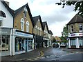
Barrack Corner, Hollybush Lane, Sevenoaks
Image: © Chris Whippet
Taken: 6 May 2015
0.08 miles