IMAGES TAKEN NEAR TO
TN13 3EZ
Introduction
This page details the photographs taken nearby to TN13 3EZ by members of the Geograph project.
The Geograph project started in 2005 with the aim of publishing, organising and preserving representative images for every square kilometre of Great Britain, Ireland and the Isle of Man.

There are currently over 7.5m images from over14,400 individuals and you can help contribute to the project by visiting https://www.geograph.org.uk
Image Map
Images are licensed for reuse under creativecommons.org/licenses/by-sa/2.0
Notes
- Clicking on the map will re-center to the selected point.
- The higher the marker number, the further away the image location is from the centre of the postcode.
Image Listing (78 Images Found)
Images are licensed for reuse under creativecommons.org/licenses/by-sa/2.0
Image
Details
Distance
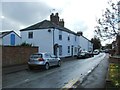
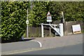
1
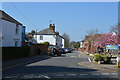
Older buildings on Bradbourne Road, St John's
Image: © Robin Webster
Taken: 9 Dec 2011
0.04 miles
2
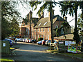
Sevenoaks Adult Education Centre
On Bradbourne Road.
Image: © Robin Webster
Taken: 9 Dec 2011
0.08 miles
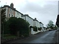
4
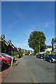
Amherst Road
Looking along Amherst Road between Bradbourne Road and St. John's Road.
Image: © DS Pugh
Taken: 11 Sep 2021
0.09 miles
5
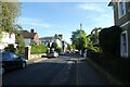
Looking along St. John's Road
Looking along the road towards the junction with Bradbourne Road.
Image: © DS Pugh
Taken: 11 Sep 2021
0.09 miles
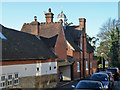
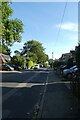
6
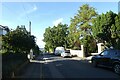
Along St. John's Road
Looking down St. John's Road which leads to the A25.
Image: © DS Pugh
Taken: 11 Sep 2021
0.09 miles
8
St. John's Road
Looking along St. John's Road to the south of Amherst Road.
Image: © DS Pugh
Taken: 11 Sep 2021
0.11 miles