IMAGES TAKEN NEAR TO
Anthony Close, SEVENOAKS, TN13 2XH
Introduction
This page details the photographs taken nearby to Anthony Close, TN13 2XH by members of the Geograph project.
The Geograph project started in 2005 with the aim of publishing, organising and preserving representative images for every square kilometre of Great Britain, Ireland and the Isle of Man.

There are currently over 7.5m images from over14,400 individuals and you can help contribute to the project by visiting https://www.geograph.org.uk
Image Map (Loading...)


Getting Data...Please wait
Leaflet Map data © OpenStreetMap
Images are licensed for reuse under creativecommons.org/licenses/by-sa/2.0
Notes
- Clicking on the map will re-center to the selected point.
- The higher the marker number, the further away the image location is from the centre of the postcode.
Image Listing (48 Images Found)
Images are licensed for reuse under creativecommons.org/licenses/by-sa/2.0
Image
Details
Distance
1
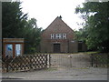
Dunton Green Free Church
On Station Road.
Image: © David Anstiss
Taken: 16 Aug 2009
0.04 miles
9
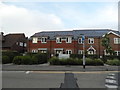
New houses on London Road, Dunton Green
Image: © David Howard
Taken: 12 Jun 2016
0.08 miles
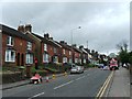
10
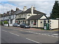
The Miners Arms, Public House, Dunton Green
This pub is on the junction of 22 London Road (on the left) and Darenth Lane (on the right).
Image: © David Anstiss
Taken: 16 Aug 2009
0.09 miles