IMAGES TAKEN NEAR TO
Chevening Road, SEVENOAKS, TN13 2RY
Introduction
This page details the photographs taken nearby to Chevening Road, TN13 2RY by members of the Geograph project.
The Geograph project started in 2005 with the aim of publishing, organising and preserving representative images for every square kilometre of Great Britain, Ireland and the Isle of Man.

There are currently over 7.5m images from over14,400 individuals and you can help contribute to the project by visiting https://www.geograph.org.uk
Image Map (Loading...)


Getting Data...Please wait
Leaflet Map data © OpenStreetMap
Images are licensed for reuse under creativecommons.org/licenses/by-sa/2.0
Notes
- Clicking on the map will re-center to the selected point.
- The higher the marker number, the further away the image location is from the centre of the postcode.
Image Listing (120 Images Found)
Images are licensed for reuse under creativecommons.org/licenses/by-sa/2.0
Image
Details
Distance
2
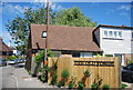
Old Forge
The Old Forge is a development of 3 houses and 3 flats on Chevening Road, Chipstead. It was built around 2000. The site had previously been a water supply depot and a small office block.
Image: © Andrew Stott
Taken: 12 May 2016
0.03 miles
3
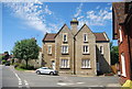
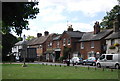
Houses, Chevening Rd
Grade II listed. http://www.britishlistedbuildings.co.uk/en-356975-1-and-3-chevening
Image: © N Chadwick
Taken: 26 Jun 2011
0.03 miles
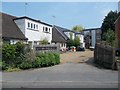
6
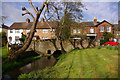
Bridge over mill stream, Chipstead
This mill stream was diverted from the River Darent, which flows a few yards to the south. This stone bridge carries Chevening Road over the stream.
Image: © Ian Capper
Taken: 2 May 2008
0.04 miles
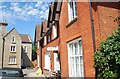
7
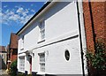
18th Century cottage, Chipstead
Grade II listed. http://www.britishlistedbuildings.co.uk/en-356982-5-chevening
Image: © N Chadwick
Taken: 26 Jun 2011
0.04 miles
8
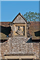
Detail, former estate workers cottages
Crest on central gable of the former estate workers cottages in Chipstead Square - see Image
Image: © Ian Capper
Taken: 25 May 2012
0.05 miles
9
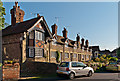
Former estate workers cottages
Former estate workers' cottages in Chipstead Square, 2-16 High Street, built in 1841 by Fredrick Perkins, owner of Chipstead Place, on the site of a former inn, the White Hart. Both the buildings themselves and the wall in front are grade II listed - see www.historicengland.org.uk/listing/the-list/list-entry/1262305 and www.historicengland.org.uk/listing/the-list/list-entry/1085865 respectively.
For close up of left hand gable see Image and for close up of crest on central gable see Image
Image: © Ian Capper
Taken: 25 May 2012
0.05 miles
10
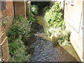
River Darenth in Chipstead
This small river leads under Chevening Road then through the Kent countryside to Dartford.
Image: © David Anstiss
Taken: 16 Aug 2009
0.05 miles