IMAGES TAKEN NEAR TO
Julians Way, SEVENOAKS, TN13 2PE
Introduction
This page details the photographs taken nearby to Julians Way, TN13 2PE by members of the Geograph project.
The Geograph project started in 2005 with the aim of publishing, organising and preserving representative images for every square kilometre of Great Britain, Ireland and the Isle of Man.

There are currently over 7.5m images from over14,400 individuals and you can help contribute to the project by visiting https://www.geograph.org.uk
Image Map
Images are licensed for reuse under creativecommons.org/licenses/by-sa/2.0
Notes
- Clicking on the map will re-center to the selected point.
- The higher the marker number, the further away the image location is from the centre of the postcode.
Image Listing (30 Images Found)
Images are licensed for reuse under creativecommons.org/licenses/by-sa/2.0
Image
Details
Distance
5
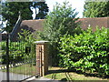
New Beacon School Chapel
On Britains Lane. For use of the school only.
Image: © David Anstiss
Taken: 16 Aug 2009
0.10 miles
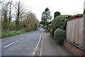
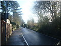
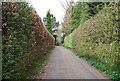
7
Brittains Lane, Sevenoaks
Brittains Lane on the outskirts of Sevenoaks, Kent.
Image: © Malc McDonald
Taken: 13 Oct 2018
0.11 miles
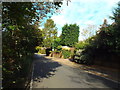
10
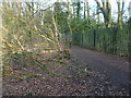
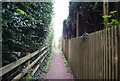
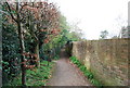
Footpath to Brittains Lane
This footpath leads from Dibden lane near the A21 to Brittains Lane. The grounds of The New Beacon School are beyond the railings to the right.
Image: © Marathon
Taken: 14 Mar 2015
0.13 miles