IMAGES TAKEN NEAR TO
Stanhope Way, SEVENOAKS, TN13 2DZ
Introduction
This page details the photographs taken nearby to Stanhope Way, TN13 2DZ by members of the Geograph project.
The Geograph project started in 2005 with the aim of publishing, organising and preserving representative images for every square kilometre of Great Britain, Ireland and the Isle of Man.

There are currently over 7.5m images from over14,400 individuals and you can help contribute to the project by visiting https://www.geograph.org.uk
Image Map
Images are licensed for reuse under creativecommons.org/licenses/by-sa/2.0
Notes
- Clicking on the map will re-center to the selected point.
- The higher the marker number, the further away the image location is from the centre of the postcode.
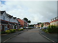
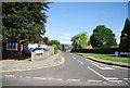
Image Listing (10 Images Found)
Images are licensed for reuse under creativecommons.org/licenses/by-sa/2.0
Image
Details
Distance
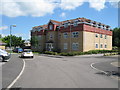
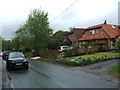
7
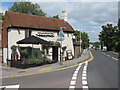
The Bullfinch Public House, Riverhead
On the junction of the A224 London Road (on right) and Bullfinch Lane (on the left).
Image: © David Anstiss
Taken: 16 Aug 2009
0.24 miles
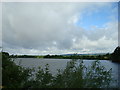
10
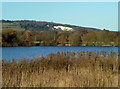
View towards the North Downs
The lake, formerly sand and gravel workings, is now used for yachting.
Image: © Robin Webster
Taken: 12 Dec 2011
0.25 miles