IMAGES TAKEN NEAR TO
Hopgarden Lane, SEVENOAKS, TN13 1PX
Introduction
This page details the photographs taken nearby to Hopgarden Lane, TN13 1PX by members of the Geograph project.
The Geograph project started in 2005 with the aim of publishing, organising and preserving representative images for every square kilometre of Great Britain, Ireland and the Isle of Man.

There are currently over 7.5m images from over14,400 individuals and you can help contribute to the project by visiting https://www.geograph.org.uk
Image Map (Loading...)


Getting Data...Please wait
Leaflet Map data © OpenStreetMap
Images are licensed for reuse under creativecommons.org/licenses/by-sa/2.0
Notes
- Clicking on the map will re-center to the selected point.
- The higher the marker number, the further away the image location is from the centre of the postcode.
Image Listing (24 Images Found)
Images are licensed for reuse under creativecommons.org/licenses/by-sa/2.0
Image
Details
Distance
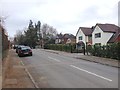
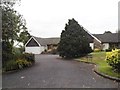
3

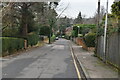
Grassy Lane, Sevenoaks
This is what you call a leafy suburb.
Image: © Bill Boaden
Taken: 23 Jun 2012
0.10 miles
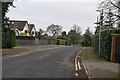
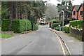
9
Oak Lane
The road connects to the Tonbridge Road.
Image: © Oast House Archive
Taken: 13 Apr 2010
0.12 miles
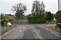
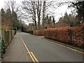
10
Modern bungalow on Grassy Lane, Sevenoaks
Image: © David Howard
Taken: 17 Aug 2015
0.13 miles