IMAGES TAKEN NEAR TO
Hopgarden Lane, SEVENOAKS, TN13 1PU
Introduction
This page details the photographs taken nearby to Hopgarden Lane, TN13 1PU by members of the Geograph project.
The Geograph project started in 2005 with the aim of publishing, organising and preserving representative images for every square kilometre of Great Britain, Ireland and the Isle of Man.

There are currently over 7.5m images from over14,400 individuals and you can help contribute to the project by visiting https://www.geograph.org.uk
Image Map
Images are licensed for reuse under creativecommons.org/licenses/by-sa/2.0
Notes
- Clicking on the map will re-center to the selected point.
- The higher the marker number, the further away the image location is from the centre of the postcode.
Image Listing (17 Images Found)
Images are licensed for reuse under creativecommons.org/licenses/by-sa/2.0
Image
Details
Distance
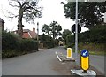
1
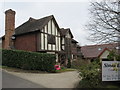
No2 Pocket Hill
A recent 'Tudor style' new build house.
Image: © David Anstiss
Taken: 22 Mar 2015
0.06 miles
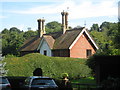
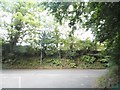
4

Byway to Fig Street
This byway leads from Ashgrove Road to Oak Lane.
Image: © David Anstiss
Taken: 16 Aug 2009
0.13 miles

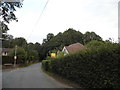
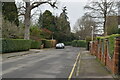
6
Ashgrove Road at the junction of Oak Road
Image: © David Howard
Taken: 17 Aug 2015
0.16 miles
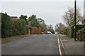
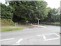
10
Oak Lane at the junction of Dibden Lane
Image: © David Howard
Taken: 17 Aug 2015
0.19 miles