IMAGES TAKEN NEAR TO
Oakhill Road, SEVENOAKS, TN13 1NQ
Introduction
This page details the photographs taken nearby to Oakhill Road, TN13 1NQ by members of the Geograph project.
The Geograph project started in 2005 with the aim of publishing, organising and preserving representative images for every square kilometre of Great Britain, Ireland and the Isle of Man.

There are currently over 7.5m images from over14,400 individuals and you can help contribute to the project by visiting https://www.geograph.org.uk
Image Map (Loading...)


Getting Data...Please wait
Leaflet Map data © OpenStreetMap
Images are licensed for reuse under creativecommons.org/licenses/by-sa/2.0
Notes
- Clicking on the map will re-center to the selected point.
- The higher the marker number, the further away the image location is from the centre of the postcode.
Image Listing (190 Images Found)
Images are licensed for reuse under creativecommons.org/licenses/by-sa/2.0
Image
Details
Distance
1
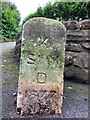
Old Boundary Marker
Parish Boundary Marker on west side of Oakhill Road, outside No.24. On the boundary of St Mary Kippington, SEVENOAKS. Inscribed K / St M / D / 1877 / No.6.
Milestone Society National ID: KE_SEVSTM06pb
Image: © M Barrow
Taken: 26 Jan 2019
0.06 miles

9
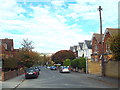
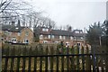
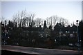
Granville Road, Sevenoaks
Granville Road is a residential road in Sevenoaks, in Kent. The North Downs ridge can be seen in the far distance in this image.
Image: © Malc McDonald
Taken: 13 Oct 2018
0.13 miles
10
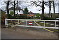
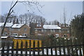
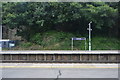
Barrier at the end of Redlands Rd, Kippington Rd
Image: © N Chadwick
Taken: 7 Apr 2009
0.13 miles