IMAGES TAKEN NEAR TO
Marle Place Road, TONBRIDGE, TN12 8DS
Introduction
This page details the photographs taken nearby to Marle Place Road, TN12 8DS by members of the Geograph project.
The Geograph project started in 2005 with the aim of publishing, organising and preserving representative images for every square kilometre of Great Britain, Ireland and the Isle of Man.

There are currently over 7.5m images from over14,400 individuals and you can help contribute to the project by visiting https://www.geograph.org.uk
Image Map (Loading...)


Getting Data...Please wait
Leaflet Map data © OpenStreetMap
Images are licensed for reuse under creativecommons.org/licenses/by-sa/2.0
Notes
- Clicking on the map will re-center to the selected point.
- The higher the marker number, the further away the image location is from the centre of the postcode.
Image Listing (20 Images Found)
Images are licensed for reuse under creativecommons.org/licenses/by-sa/2.0
Image
Details
Distance


3
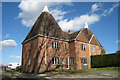
Highlands Oast, Marle Place Road, Horsmonden, Kent
The oast has been converted to two dwellings but the nearest Westerly half is currently vacant.
Image: © Oast House Archive
Taken: 3 Mar 2008
0.02 miles
4
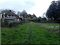
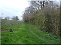
Footpath near Hazel Street
This footpath from Sprivers meets the junction of Marle Place Road and Lamberhurst Road, just beyond the houses ahead.
Image: © Marathon
Taken: 21 Nov 2020
0.09 miles
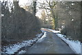
10
View from the footpath near Hazel Street
This is the view from the footpath between Sprivers and the junction of Marle Place Road and Lamberhurst Road.
Image: © Marathon
Taken: 21 Nov 2020
0.18 miles