IMAGES TAKEN NEAR TO
Lewes Heath, TONBRIDGE, TN12 8AF
Introduction
This page details the photographs taken nearby to Lewes Heath, TN12 8AF by members of the Geograph project.
The Geograph project started in 2005 with the aim of publishing, organising and preserving representative images for every square kilometre of Great Britain, Ireland and the Isle of Man.

There are currently over 7.5m images from over14,400 individuals and you can help contribute to the project by visiting https://www.geograph.org.uk
Image Map
Images are licensed for reuse under creativecommons.org/licenses/by-sa/2.0
Notes
- Clicking on the map will re-center to the selected point.
- The higher the marker number, the further away the image location is from the centre of the postcode.
Image Listing (53 Images Found)
Images are licensed for reuse under creativecommons.org/licenses/by-sa/2.0
Image
Details
Distance
1
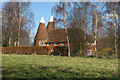
Hammonds, Spelmonden Road, Horsmonden, Kent
Two round kiln oast house.
Image: © Oast House Archive
Taken: 3 Mar 2008
0.02 miles
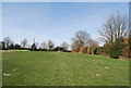
2
High Weald Landscape Trail near Lewes Heath
Image: © N Chadwick
Taken: 10 Apr 2010
0.04 miles
5
High Weald Landscape Trail heading north
Image: © N Chadwick
Taken: 10 Apr 2010
0.04 miles
6
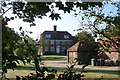
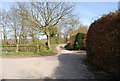
Lewes Heath House
Seen from the footpath to Brick Kiln Lane.
Image: © David Anstiss
Taken: 26 Sep 2009
0.04 miles
8
High Weald Landscape Trail heading north
Image: © N Chadwick
Taken: 10 Apr 2010
0.05 miles
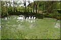
9
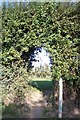
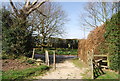
The High Weald Landscape Trail at Lewes Heath
The long distance path leads from Rectory Park towards Hazel Street. It passes through an hedge archway towards an apple orchard.
Image: © David Anstiss
Taken: 26 Sep 2009
0.05 miles
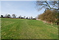
10
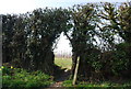
High Weald Landscape Trail going through a hedge, Lewes Heath
Image: © N Chadwick
Taken: 10 Apr 2010
0.05 miles