IMAGES TAKEN NEAR TO
Maidstone Road, TONBRIDGE, TN12 7LQ
Introduction
This page details the photographs taken nearby to Maidstone Road, TN12 7LQ by members of the Geograph project.
The Geograph project started in 2005 with the aim of publishing, organising and preserving representative images for every square kilometre of Great Britain, Ireland and the Isle of Man.

There are currently over 7.5m images from over14,400 individuals and you can help contribute to the project by visiting https://www.geograph.org.uk
Image Map
Images are licensed for reuse under creativecommons.org/licenses/by-sa/2.0
Notes
- Clicking on the map will re-center to the selected point.
- The higher the marker number, the further away the image location is from the centre of the postcode.
Image Listing (37 Images Found)
Images are licensed for reuse under creativecommons.org/licenses/by-sa/2.0
Image
Details
Distance
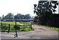
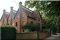
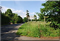
2
Farm buildings off Maidstone Rd, Matfield
Image: © N Chadwick
Taken: 14 Jun 2009
0.05 miles
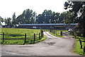
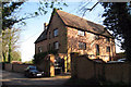
5
Friars Oast, Maidstone Road, Matfield
Image: © Oast House Archive
Taken: 9 Sep 2020
0.10 miles
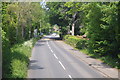
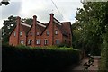
6
Friars Oast, Maidstone Road, Matfield, Kent
Image: © Oast House Archive
Taken: 13 Apr 2009
0.10 miles
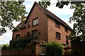
7
Friars Oast, Maidstone Road, Matfield
Image: © Oast House Archive
Taken: 9 Sep 2020
0.10 miles
8
Friars Oast, Maidstone Road, Matfield
Image: © Oast House Archive
Taken: 9 Sep 2020
0.10 miles
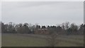
10
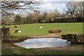
Equestrian gymkhana at Lodge Farm
Image: © Oast House Archive
Taken: 18 Feb 2018
0.12 miles