IMAGES TAKEN NEAR TO
Hastings Road, TONBRIDGE, TN12 7HB
Introduction
This page details the photographs taken nearby to Hastings Road, TN12 7HB by members of the Geograph project.
The Geograph project started in 2005 with the aim of publishing, organising and preserving representative images for every square kilometre of Great Britain, Ireland and the Isle of Man.

There are currently over 7.5m images from over14,400 individuals and you can help contribute to the project by visiting https://www.geograph.org.uk
Image Map
Images are licensed for reuse under creativecommons.org/licenses/by-sa/2.0
Notes
- Clicking on the map will re-center to the selected point.
- The higher the marker number, the further away the image location is from the centre of the postcode.
Image Listing (64 Images Found)
Images are licensed for reuse under creativecommons.org/licenses/by-sa/2.0
Image
Details
Distance
2
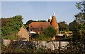
Kipping's Cross Oast, Hastings Road, Brenchley, Kent
Image: © Oast House Archive
Taken: 24 Sep 2006
0.01 miles

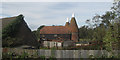
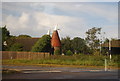
5
Kippings Cross Oast
This is a twin Oast, but only one kiln is visible from this angle.
Image: © Julian P Guffogg
Taken: 8 Mar 2010
0.02 miles
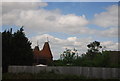
6

Kipping's Cross Oast, Hastings Road, Brenchley, Kent
Image: © Oast House Archive
Taken: 24 Sep 2006
0.02 miles
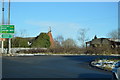
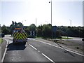
9
A21 approaches Kipping's Cross roundabout
At this roundabout on the Hastings Road (A21) Dundale Road is on the right and Maidstone Road to the left.
Image: © Stuart Logan
Taken: 26 May 2012
0.03 miles
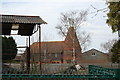
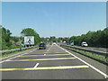
10
Roundabout at the end of the Pembury bypass
Image: © N Chadwick
Taken: 15 Sep 2010
0.04 miles