IMAGES TAKEN NEAR TO
Bramble Reed Lane, TONBRIDGE, TN12 7ET
Introduction
This page details the photographs taken nearby to Bramble Reed Lane, TN12 7ET by members of the Geograph project.
The Geograph project started in 2005 with the aim of publishing, organising and preserving representative images for every square kilometre of Great Britain, Ireland and the Isle of Man.

There are currently over 7.5m images from over14,400 individuals and you can help contribute to the project by visiting https://www.geograph.org.uk
Image Map
Images are licensed for reuse under creativecommons.org/licenses/by-sa/2.0
Notes
- Clicking on the map will re-center to the selected point.
- The higher the marker number, the further away the image location is from the centre of the postcode.
Image Listing (24 Images Found)
Images are licensed for reuse under creativecommons.org/licenses/by-sa/2.0
Image
Details
Distance
3
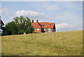
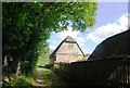
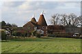
Half timbered & weatherboarded building, Lodge Farm
Image: © N Chadwick
Taken: 14 Jun 2009
0.10 miles
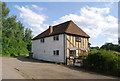
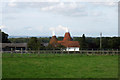
4
Lodge Farm Oast, Bramble Reed Lane, Matfield, Kent
Two round kiln oast house. A single round kiln oast house with additional roundel to side.
Also see Image
Image: © Oast House Archive
Taken: 24 Sep 2006
0.10 miles
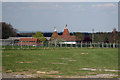
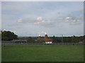
9
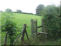
Stile near Playfoots House
This stile is on a footpath leading from South Farm to the B2160 Maidstone Road.
Image: © David Anstiss
Taken: 9 Aug 2009
0.13 miles
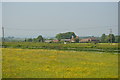
10

Two trees on the footpath south of Lodge Farm
Image: © N Chadwick
Taken: 14 Jun 2009
0.14 miles