IMAGES TAKEN NEAR TO
Cinder Hill Wood, Five Wents, TONBRIDGE, TN12 7ED
Introduction
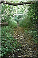
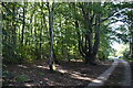
This page details the photographs taken nearby to Cinder Hill Wood, Five Wents, TN12 7ED by members of the Geograph project.
The Geograph project started in 2005 with the aim of publishing, organising and preserving representative images for every square kilometre of Great Britain, Ireland and the Isle of Man.

There are currently over 7.5m images from over14,400 individuals and you can help contribute to the project by visiting https://www.geograph.org.uk
Image Map
Images are licensed for reuse under creativecommons.org/licenses/by-sa/2.0
Notes
- Clicking on the map will re-center to the selected point.
- The higher the marker number, the further away the image location is from the centre of the postcode.
Image Listing (17 Images Found)
Images are licensed for reuse under creativecommons.org/licenses/by-sa/2.0
Image
Details
Distance
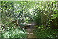
3
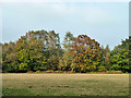
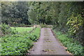
Across the playing field
This is viewed from the concrete track to the Cinderhill Wood car park. The field is called a 'football field' on the leaflet for the woods, yet it had long grass which has been roughly mown. Perhaps it is an ex-football field.
Image: © Robin Webster
Taken: 24 Oct 2012
0.10 miles