IMAGES TAKEN NEAR TO
The Foxgloves, TONBRIDGE, TN12 6RY
Introduction
This page details the photographs taken nearby to The Foxgloves, TN12 6RY by members of the Geograph project.
The Geograph project started in 2005 with the aim of publishing, organising and preserving representative images for every square kilometre of Great Britain, Ireland and the Isle of Man.

There are currently over 7.5m images from over14,400 individuals and you can help contribute to the project by visiting https://www.geograph.org.uk
Image Map (Loading...)


Getting Data...Please wait
Leaflet Map data © OpenStreetMap
Images are licensed for reuse under creativecommons.org/licenses/by-sa/2.0
Notes
- Clicking on the map will re-center to the selected point.
- The higher the marker number, the further away the image location is from the centre of the postcode.
Image Listing (58 Images Found)
Images are licensed for reuse under creativecommons.org/licenses/by-sa/2.0
Image
Details
Distance
1
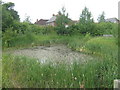
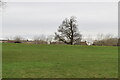
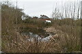
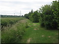
Housing Estate reservoir pond
This pond is formed by the stormwater collection from nearby houses on Green Lane. A path leads through a recreational ground near the houses leading to Church Road.
Image: © David Anstiss
Taken: 12 Jun 2009
0.04 miles
6
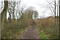
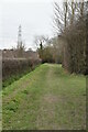
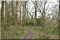
Footpath near Green Lane houses
This footpath leads from Church Road, past a housing estate recreational ground to a wood, and onto Mascall's Court Road.
Image: © David Anstiss
Taken: 12 Jun 2009
0.09 miles