IMAGES TAKEN NEAR TO
Ramsay Drive, TONBRIDGE, TN12 6GN
Introduction
This page details the photographs taken nearby to Ramsay Drive, TN12 6GN by members of the Geograph project.
The Geograph project started in 2005 with the aim of publishing, organising and preserving representative images for every square kilometre of Great Britain, Ireland and the Isle of Man.

There are currently over 7.5m images from over14,400 individuals and you can help contribute to the project by visiting https://www.geograph.org.uk
Image Map (Loading...)


Getting Data...Please wait
Leaflet Map data © OpenStreetMap
Images are licensed for reuse under creativecommons.org/licenses/by-sa/2.0
Notes
- Clicking on the map will re-center to the selected point.
- The higher the marker number, the further away the image location is from the centre of the postcode.
Image Listing (127 Images Found)
Images are licensed for reuse under creativecommons.org/licenses/by-sa/2.0
Image
Details
Distance
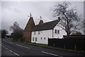
3
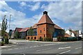
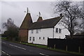
New development off Badsell Road
A mock oast house like building at the junction forming apartments.
Image: © Oast House Archive
Taken: 22 Aug 2021
0.04 miles
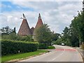
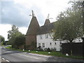
10
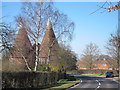
Mascalls Oast, Badsell Road, Paddock Wood, Kent
Image: © Oast House Archive
Taken: 7 Mar 2011
0.05 miles