IMAGES TAKEN NEAR TO
Mulberry Street, TONBRIDGE, TN12 6GL
Introduction
This page details the photographs taken nearby to Mulberry Street, TN12 6GL by members of the Geograph project.
The Geograph project started in 2005 with the aim of publishing, organising and preserving representative images for every square kilometre of Great Britain, Ireland and the Isle of Man.

There are currently over 7.5m images from over14,400 individuals and you can help contribute to the project by visiting https://www.geograph.org.uk
Image Map (43 Images)


Getting Data...Please wait
Leaflet Map data © OpenStreetMap
Images are licensed for reuse under creativecommons.org/licenses/by-sa/2.0
Notes
- Clicking on the map will re-center to the selected point.
- The higher the marker number, the further away the image location is from the centre of the postcode.
Image Listing (43 Images Found)
Images are licensed for reuse under creativecommons.org/licenses/by-sa/2.0
Image
Details
Distance
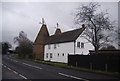
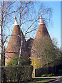
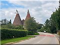
1
Mascalls Oast
Kent must have had quite a smell about it in season when all the oast houses were operational.
Image: © Robin Webster
Taken: 24 Oct 2012
0.03 miles
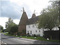
2
Mascalls Oast, Badsell Road, Paddock Wood, Kent
Image: © Oast House Archive
Taken: 7 Mar 2011
0.03 miles
3
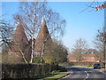
Mascalls Oast, Badsell Road, Paddock Wood, Kent
Image: © Oast House Archive
Taken: 7 Mar 2011
0.03 miles
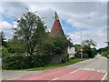
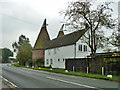
7
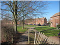
Goldings
A housing estate at the edge of Paddock Wood. Goldings is a type of hop which would have been grown on this land before the houses were built. Viewed from footpath by Badsell Road.
Image: © Oast House Archive
Taken: 7 Mar 2011
0.04 miles