IMAGES TAKEN NEAR TO
Smithers Lane, TONBRIDGE, TN12 5HS
Introduction
This page details the photographs taken nearby to Smithers Lane, TN12 5HS by members of the Geograph project.
The Geograph project started in 2005 with the aim of publishing, organising and preserving representative images for every square kilometre of Great Britain, Ireland and the Isle of Man.

There are currently over 7.5m images from over14,400 individuals and you can help contribute to the project by visiting https://www.geograph.org.uk
Image Map (Loading...)


Getting Data...Please wait
Leaflet Map data © OpenStreetMap
Images are licensed for reuse under creativecommons.org/licenses/by-sa/2.0
Notes
- Clicking on the map will re-center to the selected point.
- The higher the marker number, the further away the image location is from the centre of the postcode.
Image Listing (39 Images Found)
Images are licensed for reuse under creativecommons.org/licenses/by-sa/2.0
Image
Details
Distance

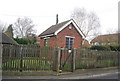
3
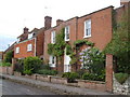
Houses in Smithers Lane, Hale Street
Attractive houses close to the A228 in East Peckham.
Image: © Derek Harper
Taken: 20 May 2006
0.10 miles
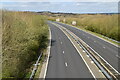

6
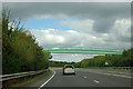
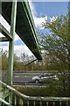
Footbridge over A228
This carries a path from Hale Street towards a Medway crossing at the site of the former Stoneham Lock.
Image: © Robin Webster
Taken: 27 Sep 2012
0.12 miles
9

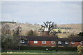
Oast House at Fuggles, Hale Court, East Peckham
Image: © Oast House Archive
Taken: 1 Jan 2003
0.12 miles
10

Hodge's Cottage
A Wealden Hall house, Grade II listed. http://www.britishlistedbuildings.co.uk/en-178806-140-144-east-peckham
Image: © N Chadwick
Taken: 5 Feb 2011
0.14 miles