IMAGES TAKEN NEAR TO
Penfold Court, TN12 0GF
Introduction
This page details the photographs taken nearby to Penfold Court, TN12 0GF by members of the Geograph project.
The Geograph project started in 2005 with the aim of publishing, organising and preserving representative images for every square kilometre of Great Britain, Ireland and the Isle of Man.

There are currently over 7.5m images from over14,400 individuals and you can help contribute to the project by visiting https://www.geograph.org.uk
Image Map (Loading...)


Getting Data...Please wait
Leaflet Map data © OpenStreetMap
Images are licensed for reuse under creativecommons.org/licenses/by-sa/2.0
Notes
- Clicking on the map will re-center to the selected point.
- The higher the marker number, the further away the image location is from the centre of the postcode.
Image Listing (21 Images Found)
Images are licensed for reuse under creativecommons.org/licenses/by-sa/2.0
Image
Details
Distance
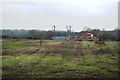
2
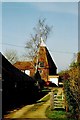
Oast House, Marden Road, Staplehurst, Kent
Image: © Oast House Archive
Taken: 1 Mar 2003
0.17 miles
3
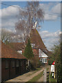
Oast House, Marden Road, Staplehurst, Kent
Single square kiln oast house.
Image: © Oast House Archive
Taken: 15 Mar 2010
0.19 miles
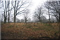
4
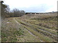
Waste Ground, Staplehurst
This is between the railway line and the industrial estate.
Image: © Danny P Robinson
Taken: 31 Mar 2013
0.21 miles
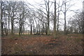
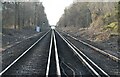
6
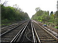
Railway to Marden
As seen from level crossing near George Street. Railway heads to Marden and then onto Paddock Wood, from Staplehurst and Ashford.
Image: © David Anstiss
Taken: 19 Apr 2009
0.21 miles
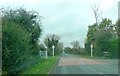
7
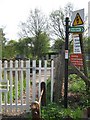
Level crossing near George Street
Footpath No.KM290 leads over the railway and then onto Station Approach near Staplehurst Station.
Image: © David Anstiss
Taken: 19 Apr 2009
0.21 miles