IMAGES TAKEN NEAR TO
Bell Lane, TONBRIDGE, TN12 0BY
Introduction
This page details the photographs taken nearby to Bell Lane, TN12 0BY by members of the Geograph project.
The Geograph project started in 2005 with the aim of publishing, organising and preserving representative images for every square kilometre of Great Britain, Ireland and the Isle of Man.

There are currently over 7.5m images from over14,400 individuals and you can help contribute to the project by visiting https://www.geograph.org.uk
Image Map
Images are licensed for reuse under creativecommons.org/licenses/by-sa/2.0
Notes
- Clicking on the map will re-center to the selected point.
- The higher the marker number, the further away the image location is from the centre of the postcode.
Image Listing (196 Images Found)
Images are licensed for reuse under creativecommons.org/licenses/by-sa/2.0
Image
Details
Distance
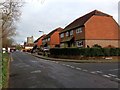
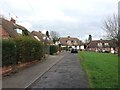
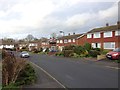
6
New houses on Bell Lane
Built on the garden area of the former Bell Inn.
Image: © Oast House Archive
Taken: 26 Jun 2018
0.07 miles
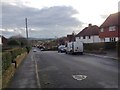
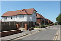
8
The King's Head Public House, Staplehurst
On junction of A229 Cranbrook Road (in front) and Bell Lane (on left).
Image: © David Anstiss
Taken: 19 Apr 2009
0.08 miles
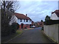
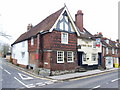
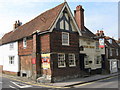
10
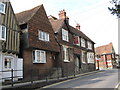
The Bell Inn, Staplehurst
Public house on junction of A229 Cranbrook Road (in front) and Bell Lane (leading left behind the pub). It is opposite St Andrews Church.
Image: © David Anstiss
Taken: 19 Apr 2009
0.08 miles