IMAGES TAKEN NEAR TO
High Street, TONBRIDGE, TN12 0AW
Introduction
This page details the photographs taken nearby to High Street, TN12 0AW by members of the Geograph project.
The Geograph project started in 2005 with the aim of publishing, organising and preserving representative images for every square kilometre of Great Britain, Ireland and the Isle of Man.

There are currently over 7.5m images from over14,400 individuals and you can help contribute to the project by visiting https://www.geograph.org.uk
Image Map (Loading...)


Getting Data...Please wait
Leaflet Map data © OpenStreetMap
Images are licensed for reuse under creativecommons.org/licenses/by-sa/2.0
Notes
- Clicking on the map will re-center to the selected point.
- The higher the marker number, the further away the image location is from the centre of the postcode.
Image Listing (205 Images Found)
Images are licensed for reuse under creativecommons.org/licenses/by-sa/2.0
Image
Details
Distance
2
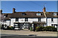
Fire Damaged Buildings on High Street
The fire started in the top floor flat of the taller white building (above shops) and spread to the neighbouring listed building. Holes in the roof were created by the fire crew to vent the building and allow access for the fire hoses. Though described as a major fire attended by 80 fire crew, little damage can be seen externally, particularly from the High Street. The majority of the fire damage was to the rear of the roof.
Image: © Oast House Archive
Taken: 14 Jul 2010
0.02 miles
7
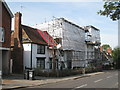
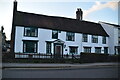
Scaffolding on High Street Buildings
Post office building and flats and neighbouring house covered in scaffold after a fire in July.
Image: © Oast House Archive
Taken: 22 Sep 2010
0.02 miles
9
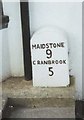
Old Milestone by the A229, Staplehurst
Carved stone post by the A229, in parish of STAPLEHURST (MAIDSTONE District), Staplehurst Post Office, in pavement by office wall, on West side of road, opposite chapel. Cranbrook stone, erected by the Maidstone & Cranbrook turnpike trust in the 19th century.
Inscription reads:-
MAIDSTONE
9
CRANBROOK
5
Kent HER listed. HER Number: TQ 74 SE 240
https://www.heritagegateway.org.uk/Gateway/Results_Single.aspx?uid=MKE78073&resourceID=1005
Milestone Society National ID: KE_MDCB09.
Image: © C Woodward
Taken: 23 Aug 2007
0.03 miles
10
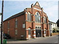
The United Reformed Church, Staplehurst
On A229 High Street. Has two foundation stones either side of front doors. The one on the left reads 'Foundation Stone Erected 1825 Enlarged 1889 A memorial to William Jull Deacon 1825 to 1877 This Stone was laid by his son John May 13th 1889'. The stone on the right reads 'This Stone was laid May 13th 1889 by TS Stokes esquire A memorial to Reverend Samuel French - Minister 1684-1691 and Reverend Jacob Chapman - Minister 1710-1795'.
Image: © David Anstiss
Taken: 19 Apr 2009
0.03 miles