IMAGES TAKEN NEAR TO
Dunks Green, TONBRIDGE, TN11 9SG
Introduction
This page details the photographs taken nearby to TN11 9SG by members of the Geograph project.
The Geograph project started in 2005 with the aim of publishing, organising and preserving representative images for every square kilometre of Great Britain, Ireland and the Isle of Man.

There are currently over 7.5m images from over14,400 individuals and you can help contribute to the project by visiting https://www.geograph.org.uk
Image Map
Images are licensed for reuse under creativecommons.org/licenses/by-sa/2.0
Notes
- Clicking on the map will re-center to the selected point.
- The higher the marker number, the further away the image location is from the centre of the postcode.
Image Listing (58 Images Found)
Images are licensed for reuse under creativecommons.org/licenses/by-sa/2.0
Image
Details
Distance
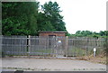
2
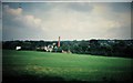
Roughway Paper Mills
Roughway Paper Mills, showing the chimney which has now been demolished. Digital photograph of projected 35mm slide.
Image: © Michael Roots
Taken: 31 Jul 1982
0.01 miles