IMAGES TAKEN NEAR TO
Long Mill Lane, TONBRIDGE, TN11 9SF
Introduction
This page details the photographs taken nearby to Long Mill Lane, TN11 9SF by members of the Geograph project.
The Geograph project started in 2005 with the aim of publishing, organising and preserving representative images for every square kilometre of Great Britain, Ireland and the Isle of Man.

There are currently over 7.5m images from over14,400 individuals and you can help contribute to the project by visiting https://www.geograph.org.uk
Image Map
Images are licensed for reuse under creativecommons.org/licenses/by-sa/2.0
Notes
- Clicking on the map will re-center to the selected point.
- The higher the marker number, the further away the image location is from the centre of the postcode.
Image Listing (33 Images Found)
Images are licensed for reuse under creativecommons.org/licenses/by-sa/2.0
Image
Details
Distance
3
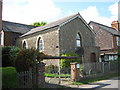
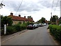
Dunk's Green Evangelical Free Church
On Long Mill Lane.
Image: © David Anstiss
Taken: 6 May 2009
0.03 miles
5
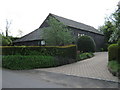
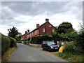
Salmons Barn
On Long Mill Lane, Dunk's Green.
Image: © David Anstiss
Taken: 6 May 2009
0.11 miles
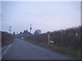
9
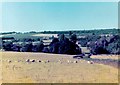
Fields at Dunk's Green
Sheep in field at Dunk's Green near Tonbridge in Kent. Scan of a 35mm photo taken in the 1980's.
Image: © Barry
Taken: Unknown
0.13 miles