IMAGES TAKEN NEAR TO
Hamptons Road, TONBRIDGE, TN11 9RE
Introduction
This page details the photographs taken nearby to Hamptons Road, TN11 9RE by members of the Geograph project.
The Geograph project started in 2005 with the aim of publishing, organising and preserving representative images for every square kilometre of Great Britain, Ireland and the Isle of Man.

There are currently over 7.5m images from over14,400 individuals and you can help contribute to the project by visiting https://www.geograph.org.uk
Image Map
Images are licensed for reuse under creativecommons.org/licenses/by-sa/2.0
Notes
- Clicking on the map will re-center to the selected point.
- The higher the marker number, the further away the image location is from the centre of the postcode.
Image Listing (25 Images Found)
Images are licensed for reuse under creativecommons.org/licenses/by-sa/2.0
Image
Details
Distance


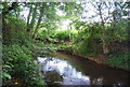
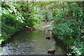
5
Single tree seen across the River Bourne
Image: © N Chadwick
Taken: 14 Jun 2009
0.17 miles
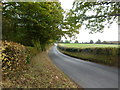
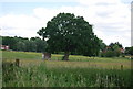
7
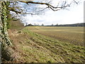
Field next to Hamptons Road
This was a lovely clear afternoon light in Kent. This field is next to the road from Hadlow to Paxtol and opposite the junction with Park Road.
Image: © Marathon
Taken: 18 Feb 2016
0.20 miles
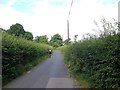
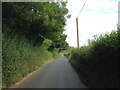
9
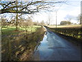
Park Road near Hadlow
This is Park Road leading away from Hamptons Road after recent rain.
Image: © Marathon
Taken: 18 Feb 2016
0.21 miles