IMAGES TAKEN NEAR TO
Crandalls, TONBRIDGE, TN11 8RF
Introduction
This page details the photographs taken nearby to Crandalls, TN11 8RF by members of the Geograph project.
The Geograph project started in 2005 with the aim of publishing, organising and preserving representative images for every square kilometre of Great Britain, Ireland and the Isle of Man.

There are currently over 7.5m images from over14,400 individuals and you can help contribute to the project by visiting https://www.geograph.org.uk
Image Map
Images are licensed for reuse under creativecommons.org/licenses/by-sa/2.0
Notes
- Clicking on the map will re-center to the selected point.
- The higher the marker number, the further away the image location is from the centre of the postcode.
Image Listing (583 Images Found)
Images are licensed for reuse under creativecommons.org/licenses/by-sa/2.0
Image
Details
Distance
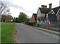
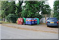
1
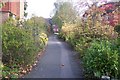
Footpath in Leigh
This path leads from Well Close to Crandalls.
Image: © David Anstiss
Taken: 18 Oct 2009
0.03 miles
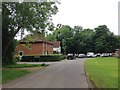
4
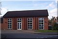
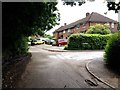
Jessica's Hall, Leigh
At the junction of Crandalls (on the left) and The Green (on the right).
Built in 2003. Holds various social activities.
Image: © David Anstiss
Taken: 18 Oct 2009
0.05 miles