IMAGES TAKEN NEAR TO
The Green, TONBRIDGE, TN11 8QP
Introduction
This page details the photographs taken nearby to The Green, TN11 8QP by members of the Geograph project.
The Geograph project started in 2005 with the aim of publishing, organising and preserving representative images for every square kilometre of Great Britain, Ireland and the Isle of Man.

There are currently over 7.5m images from over14,400 individuals and you can help contribute to the project by visiting https://www.geograph.org.uk
Image Map (Loading...)


Getting Data...Please wait
Leaflet Map data © OpenStreetMap
Images are licensed for reuse under creativecommons.org/licenses/by-sa/2.0
Notes
- Clicking on the map will re-center to the selected point.
- The higher the marker number, the further away the image location is from the centre of the postcode.
Image Listing (555 Images Found)
Images are licensed for reuse under creativecommons.org/licenses/by-sa/2.0
Image
Details
Distance
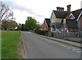
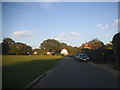
3
Jessica's Hall, Leigh
At the junction of Crandalls (on the left) and The Green (on the right).
Built in 2003. Holds various social activities.
Image: © David Anstiss
Taken: 18 Oct 2009
0.03 miles
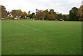
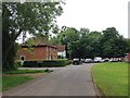
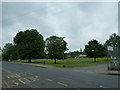
8
Village Green, Leigh
Looking north across the green towards the church.
Image: © Chris Heaton
Taken: 15 Sep 2010
0.04 miles
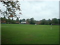
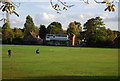
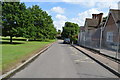
10
Approaching a recreation ground at Leigh
Image: © Basher Eyre
Taken: 2 Jun 2012
0.04 miles