IMAGES TAKEN NEAR TO
Leigh, TONBRIDGE, TN11 8PP
Introduction
This page details the photographs taken nearby to TN11 8PP by members of the Geograph project.
The Geograph project started in 2005 with the aim of publishing, organising and preserving representative images for every square kilometre of Great Britain, Ireland and the Isle of Man.

There are currently over 7.5m images from over14,400 individuals and you can help contribute to the project by visiting https://www.geograph.org.uk
Image Map (Loading...)


Getting Data...Please wait
Leaflet Map data © OpenStreetMap
Images are licensed for reuse under creativecommons.org/licenses/by-sa/2.0
Notes
- Clicking on the map will re-center to the selected point.
- The higher the marker number, the further away the image location is from the centre of the postcode.
Image Listing (58 Images Found)
Images are licensed for reuse under creativecommons.org/licenses/by-sa/2.0
Image
Details
Distance
5
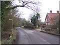
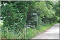
Footpath cross Copping's Road
This road leads from Philpots Lane towards Charcott. The path on the left leads to Leigh Park Farm and Home Covert. The path on the right leads to Wickhurst Farm. In the background is Wickhurst Brook.
Image: © David Anstiss
Taken: 6 Feb 2010
0.02 miles
6
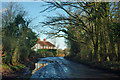
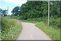
A wet Copping's Road
This road suffers from mild flooding, this being a better part. It appears more a case of poor drainage into the nearby brook than the brook overflowing.
Image: © Robin Webster
Taken: 2 Jan 2012
0.02 miles