IMAGES TAKEN NEAR TO
Leigh, TONBRIDGE, TN11 8HP
Introduction
This page details the photographs taken nearby to TN11 8HP by members of the Geograph project.
The Geograph project started in 2005 with the aim of publishing, organising and preserving representative images for every square kilometre of Great Britain, Ireland and the Isle of Man.

There are currently over 7.5m images from over14,400 individuals and you can help contribute to the project by visiting https://www.geograph.org.uk
Image Map
Images are licensed for reuse under creativecommons.org/licenses/by-sa/2.0
Notes
- Clicking on the map will re-center to the selected point.
- The higher the marker number, the further away the image location is from the centre of the postcode.
Image Listing (93 Images Found)
Images are licensed for reuse under creativecommons.org/licenses/by-sa/2.0
Image
Details
Distance
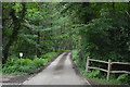
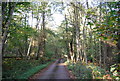
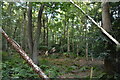
3
B2027 along Price's Wood
Towards Leigh.
Image: © Julian P Guffogg
Taken: 23 Jan 2015
0.03 miles
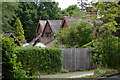
4
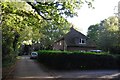
Large house on the western edge of Leigh, B2027
Image: © N Chadwick
Taken: 10 Oct 2009
0.05 miles
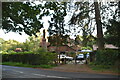
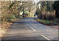
10
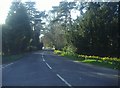
Penshurst Road, Chiddingstone Causeway
Image: © David Howard
Taken: 1 Apr 2012
0.06 miles