IMAGES TAKEN NEAR TO
Rogues Hill, TONBRIDGE, TN11 8BB
Introduction
This page details the photographs taken nearby to Rogues Hill, TN11 8BB by members of the Geograph project.
The Geograph project started in 2005 with the aim of publishing, organising and preserving representative images for every square kilometre of Great Britain, Ireland and the Isle of Man.

There are currently over 7.5m images from over14,400 individuals and you can help contribute to the project by visiting https://www.geograph.org.uk
Image Map (Loading...)


Getting Data...Please wait
Leaflet Map data © OpenStreetMap
Images are licensed for reuse under creativecommons.org/licenses/by-sa/2.0
Notes
- Clicking on the map will re-center to the selected point.
- The higher the marker number, the further away the image location is from the centre of the postcode.
Image Listing (51 Images Found)
Images are licensed for reuse under creativecommons.org/licenses/by-sa/2.0
Image
Details
Distance


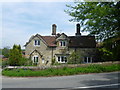
4
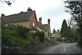
Almshouses, Penshurst
Late Georgian almshouses built outside this ancient West Kent village. Grade II listed. http://www.britishlistedbuildings.co.uk/en-446421-almshouses-at-corner-of-elliotts-farm-la
Image: © N Chadwick
Taken: 29 Oct 2008
0.06 miles
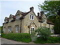
5
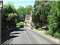
Almshouses on Rogue's Hill
The stone inscription between the middle windows says "GIVEN TO THE PARISH OF PENSHURST AD 1833 BY SIR SHELLEY SIDNEY BART AND PRIVATE SUBSCRIBERS. ENLARGED AND IMPROVED 1897 BY PUBLIC SUBSCRIPTION TO COMMEMORATE THE 60th YEAR OF THE REIGN OF QUEEN VICTORIA"
Image: © Marathon
Taken: 5 May 2014
0.07 miles
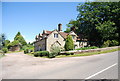
6
Almshouses on Rogue's Hill near Penshurst
The stone inscription between the middle windows on the right says "GIVEN TO THE PARISH OF PENSHURST AD 1833 BY SIR SHELLEY SIDNEY BART AND PRIVATE SUBSCRIBERS. ENLARGED AND IMPROVED 1897 BY PUBLIC SUBSCRIPTION TO COMMEMORATE THE 60th YEAR OF THE REIGN OF QUEEN VICTORIA"
Image: © Marathon
Taken: 5 May 2014
0.07 miles
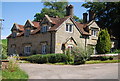
7
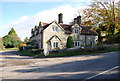
Almshouses
Grade II listed. http://www.britishlistedbuildings.co.uk/en-446421-almshouses-at-corner-of-elliotts-farm-la
Image: © N Chadwick
Taken: 10 Jun 2014
0.08 miles
8
Almshouses
Grade II listed. http://www.britishlistedbuildings.co.uk/en-446421-almshouses-at-corner-of-elliotts-farm-la
Image: © N Chadwick
Taken: 10 Jun 2014
0.08 miles