IMAGES TAKEN NEAR TO
Tudeley Lane, TONBRIDGE, TN11 0QJ
Introduction
This page details the photographs taken nearby to Tudeley Lane, TN11 0QJ by members of the Geograph project.
The Geograph project started in 2005 with the aim of publishing, organising and preserving representative images for every square kilometre of Great Britain, Ireland and the Isle of Man.

There are currently over 7.5m images from over14,400 individuals and you can help contribute to the project by visiting https://www.geograph.org.uk
Image Map (Loading...)


Getting Data...Please wait
Leaflet Map data © OpenStreetMap
Images are licensed for reuse under creativecommons.org/licenses/by-sa/2.0
Notes
- Clicking on the map will re-center to the selected point.
- The higher the marker number, the further away the image location is from the centre of the postcode.
Image Listing (72 Images Found)
Images are licensed for reuse under creativecommons.org/licenses/by-sa/2.0
Image
Details
Distance
3
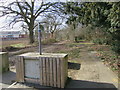
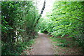
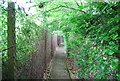
Tudeley Lane
This section of Tudeley Lane is now closed to vehicles.
Image: © Oast House Archive
Taken: 2 Mar 2017
0.08 miles
4
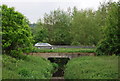
A26, Woodgate Way, Tonbridge's easterly by-pass crosses a stream
Image: © N Chadwick
Taken: 14 May 2009
0.09 miles
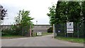
7
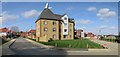
New estate off Tudeley Lane
The building to the foreground has been built in the style of a Malthouse.
The site was formerly the Priory Works.
Image: © Oast House Archive
Taken: 2 Mar 2017
0.11 miles
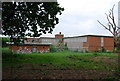
8
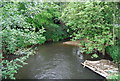
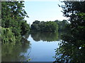
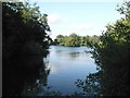
A tributary of the River Medway from Five Oak Green Rd
Image: © N Chadwick
Taken: 14 May 2009
0.12 miles