IMAGES TAKEN NEAR TO
Hartlake Road, TONBRIDGE, TN11 0PG
Introduction
This page details the photographs taken nearby to Hartlake Road, TN11 0PG by members of the Geograph project.
The Geograph project started in 2005 with the aim of publishing, organising and preserving representative images for every square kilometre of Great Britain, Ireland and the Isle of Man.

There are currently over 7.5m images from over14,400 individuals and you can help contribute to the project by visiting https://www.geograph.org.uk
Image Map (Loading...)


Getting Data...Please wait
Leaflet Map data © OpenStreetMap
Images are licensed for reuse under creativecommons.org/licenses/by-sa/2.0
Notes
- Clicking on the map will re-center to the selected point.
- The higher the marker number, the further away the image location is from the centre of the postcode.
Image Listing (30 Images Found)
Images are licensed for reuse under creativecommons.org/licenses/by-sa/2.0
Image
Details
Distance
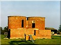
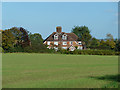
3
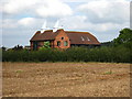
Latters Oast, Hartlake Road, Tudeley, Kent
Image: © Oast House Archive
Taken: 16 Sep 2007
0.02 miles
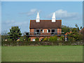
5
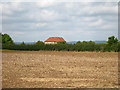
Wenhams Oast, Hartlake Road, Tudeley, Kent
Recently rebuilt and converted to dwelling.
Image: © Oast House Archive
Taken: 16 Sep 2007
0.09 miles
6
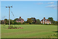
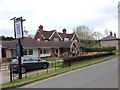
Houses, Tudeley Hale
Hale Farm Cottages on the left, Latters Farm Cottages on the right.
Image: © Robin Webster
Taken: 16 Oct 2012
0.11 miles
7
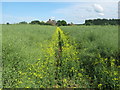
Footpath to Hartlake Road
On a path from Tudeley Road, via Postern Park farmland. Going through Oil Seed Rape field.
Image: © David Anstiss
Taken: 7 Jun 2009
0.11 miles
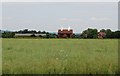
9
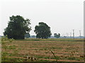
Two trees in a fallow field, North of Tudeley.
Image: © N Chadwick
Taken: 25 Jun 2006
0.13 miles