IMAGES TAKEN NEAR TO
High Street, TONBRIDGE, TN11 0EE
Introduction
This page details the photographs taken nearby to High Street, TN11 0EE by members of the Geograph project.
The Geograph project started in 2005 with the aim of publishing, organising and preserving representative images for every square kilometre of Great Britain, Ireland and the Isle of Man.

There are currently over 7.5m images from over14,400 individuals and you can help contribute to the project by visiting https://www.geograph.org.uk
Image Map (Loading...)


Getting Data...Please wait
Leaflet Map data © OpenStreetMap
Images are licensed for reuse under creativecommons.org/licenses/by-sa/2.0
Notes
- Clicking on the map will re-center to the selected point.
- The higher the marker number, the further away the image location is from the centre of the postcode.
Image Listing (219 Images Found)
Images are licensed for reuse under creativecommons.org/licenses/by-sa/2.0
Image
Details
Distance
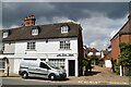
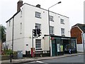
4
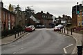
Hadlow Post Office
This is the post office, temporarily closed because a vehicle of some description was driven through the shop window.
Image: © Chris Heaton
Taken: 16 Nov 2008
0.01 miles
10
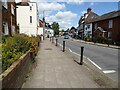
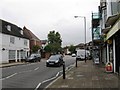
The village of Hadlow
The A26 passing through the village of Hadlow.
Image: © Philip Halling
Taken: 10 Aug 2021
0.01 miles