IMAGES TAKEN NEAR TO
Kenward Court, TONBRIDGE, TN11 0DX
Introduction
This page details the photographs taken nearby to Kenward Court, TN11 0DX by members of the Geograph project.
The Geograph project started in 2005 with the aim of publishing, organising and preserving representative images for every square kilometre of Great Britain, Ireland and the Isle of Man.

There are currently over 7.5m images from over14,400 individuals and you can help contribute to the project by visiting https://www.geograph.org.uk
Image Map
Images are licensed for reuse under creativecommons.org/licenses/by-sa/2.0
Notes
- Clicking on the map will re-center to the selected point.
- The higher the marker number, the further away the image location is from the centre of the postcode.
Image Listing (217 Images Found)
Images are licensed for reuse under creativecommons.org/licenses/by-sa/2.0
Image
Details
Distance
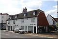
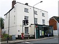
4
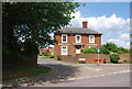
House at the junction of High St & Carpenters Lane, Hadlow
Image: © N Chadwick
Taken: 14 Jun 2009
0.03 miles
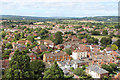
6
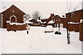
Kenward Court, Hadlow, 1987
We had very heavy snow in Kent in the winter of 1986/7, and as I recall we were snowed in for several days. The building on the left was a conversion - it had originally been one of the Kenward and Court Brewery buildings.
Image: © David Robinson
Taken: Unknown
0.04 miles
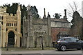
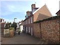
9
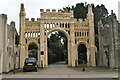
Gateway to Hadlow Castle
Grade II* listed.
Image: © N Chadwick
Taken: 17 Feb 2022
0.04 miles