IMAGES TAKEN NEAR TO
Cuckoo Lane, TONBRIDGE, TN11 0AG
Introduction
This page details the photographs taken nearby to Cuckoo Lane, TN11 0AG by members of the Geograph project.
The Geograph project started in 2005 with the aim of publishing, organising and preserving representative images for every square kilometre of Great Britain, Ireland and the Isle of Man.

There are currently over 7.5m images from over14,400 individuals and you can help contribute to the project by visiting https://www.geograph.org.uk
Image Map
Images are licensed for reuse under creativecommons.org/licenses/by-sa/2.0
Notes
- Clicking on the map will re-center to the selected point.
- The higher the marker number, the further away the image location is from the centre of the postcode.
Image Listing (9 Images Found)
Images are licensed for reuse under creativecommons.org/licenses/by-sa/2.0
Image
Details
Distance
2
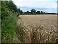
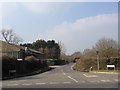
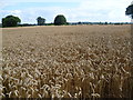
Field of wheat alongside Cuckoo Lane
Cuckoo Lane is to the left of the hedge. The A26 (Tonbridge Road) lies in the distance to the right.
Image: © Marathon
Taken: 30 Jul 2015
0.07 miles
3
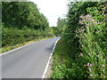
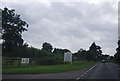
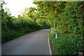
Cuckoo Lane
Cuckoo Lane passes Cuckoo Farm just ahead before meeting the A26 (Tonbridge Road) a little further on. The plant on the right is great willowherb.
Image: © Marathon
Taken: 30 Jul 2015
0.08 miles
4
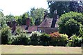
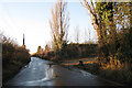
Field of wheat alongside Cuckoo Lane
The houses of Higham Wood on the northern edge of Tonbridge can be seen in the distance.
Image: © Marathon
Taken: 30 Jul 2015
0.13 miles