IMAGES TAKEN NEAR TO
Hopgarden Road, TONBRIDGE, TN10 4QU
Introduction
This page details the photographs taken nearby to Hopgarden Road, TN10 4QU by members of the Geograph project.
The Geograph project started in 2005 with the aim of publishing, organising and preserving representative images for every square kilometre of Great Britain, Ireland and the Isle of Man.

There are currently over 7.5m images from over14,400 individuals and you can help contribute to the project by visiting https://www.geograph.org.uk
Image Map
Images are licensed for reuse under creativecommons.org/licenses/by-sa/2.0
Notes
- Clicking on the map will re-center to the selected point.
- The higher the marker number, the further away the image location is from the centre of the postcode.
Image Listing (61 Images Found)
Images are licensed for reuse under creativecommons.org/licenses/by-sa/2.0
Image
Details
Distance
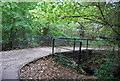
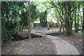
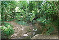
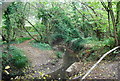
2
The Pen Stream woodland Path crosses the Pen Stream
Image: © N Chadwick
Taken: 14 Oct 2009
0.05 miles
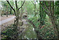
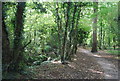
5
The Penn Stream woodland path crosses the Penn Stream, Tonbridge
This path leads from A227 Shipbourne Road to Higham Lane.
Image: © David Anstiss
Taken: 12 Jul 2009
0.07 miles
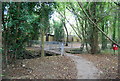
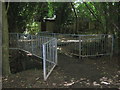
9
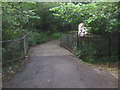
Footpath crosses over Penn Stream, Tonbridge
Path leads from Hopgarden Road to Turner Road. The path is also part of the Penn Stream woodland path leading right from A227 Shipbourne Road to Higham Lane.
Image: © David Anstiss
Taken: 12 Jul 2009
0.08 miles