IMAGES TAKEN NEAR TO
Nursery Close, TONBRIDGE, TN10 4JJ
Introduction
This page details the photographs taken nearby to Nursery Close, TN10 4JJ by members of the Geograph project.
The Geograph project started in 2005 with the aim of publishing, organising and preserving representative images for every square kilometre of Great Britain, Ireland and the Isle of Man.

There are currently over 7.5m images from over14,400 individuals and you can help contribute to the project by visiting https://www.geograph.org.uk
Image Map
Images are licensed for reuse under creativecommons.org/licenses/by-sa/2.0
Notes
- Clicking on the map will re-center to the selected point.
- The higher the marker number, the further away the image location is from the centre of the postcode.
Image Listing (64 Images Found)
Images are licensed for reuse under creativecommons.org/licenses/by-sa/2.0
Image
Details
Distance
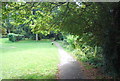
3
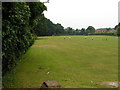
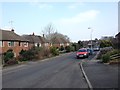
Playing fields off Higham lane, North Tonbridge
Open space in the suburbs of North Tonbridge.
Image: © N Chadwick
Taken: 25 Jun 2006
0.03 miles
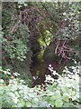
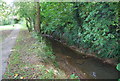

8
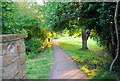
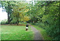
Footpath along the Pen Stream.
The Pen Stream flows through north Tonbridge. It flows through a ribbon of woodland forming a "green vein". The footpath is a recreational amenity.
Image: © N Chadwick
Taken: 20 May 2009
0.08 miles