IMAGES TAKEN NEAR TO
Landseer Close, TONBRIDGE, TN10 4AP
Introduction
This page details the photographs taken nearby to Landseer Close, TN10 4AP by members of the Geograph project.
The Geograph project started in 2005 with the aim of publishing, organising and preserving representative images for every square kilometre of Great Britain, Ireland and the Isle of Man.

There are currently over 7.5m images from over14,400 individuals and you can help contribute to the project by visiting https://www.geograph.org.uk
Image Map
Images are licensed for reuse under creativecommons.org/licenses/by-sa/2.0
Notes
- Clicking on the map will re-center to the selected point.
- The higher the marker number, the further away the image location is from the centre of the postcode.
Image Listing (64 Images Found)
Images are licensed for reuse under creativecommons.org/licenses/by-sa/2.0
Image
Details
Distance
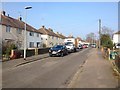
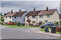
1
Landseer Close
c.1950s housing in the Cage Green area of Tonbridge, one of a number of roads in the area named after British painters.
Image: © Ian Capper
Taken: 30 Jun 2021
0.01 miles
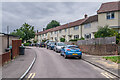
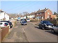
2
Knight Road
c.1950s housing in the Cage Green area of Tonbridge, one of a number of roads in the area named after British painters.
Image: © Ian Capper
Taken: 30 Jun 2021
0.04 miles
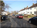
6
Knight Road
c.1950s housing in the Cage Green area of Tonbridge, one of a number of roads in the area named after British painters.
Image: © Ian Capper
Taken: 30 Jun 2021
0.07 miles
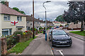
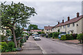
7
Whistler Road
c.1950s housing in the Cage Green area of Tonbridge. Whistler Road is one of a number of roads in the area named after painters, another being Knight Road, on the right.
Image: © Ian Capper
Taken: 30 Jun 2021
0.07 miles
8
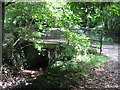
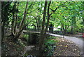
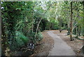
Footbridge over the Penn Stream, Tonbridge
This bridge carries a path leading from the Penn Stream woodland path, to Knight Road. The Penn Stream path leads from A227 Shipbourne Road to Higham Lane.
Image: © David Anstiss
Taken: 12 Jul 2009
0.07 miles