IMAGES TAKEN NEAR TO
Forge Lane, MARKET DRAYTON, TF9 4QN
Introduction
This page details the photographs taken nearby to Forge Lane, TF9 4QN by members of the Geograph project.
The Geograph project started in 2005 with the aim of publishing, organising and preserving representative images for every square kilometre of Great Britain, Ireland and the Isle of Man.

There are currently over 7.5m images from over14,400 individuals and you can help contribute to the project by visiting https://www.geograph.org.uk
Image Map (Loading...)


Getting Data...Please wait
Leaflet Map data © OpenStreetMap
Images are licensed for reuse under creativecommons.org/licenses/by-sa/2.0
Notes
- Clicking on the map will re-center to the selected point.
- The higher the marker number, the further away the image location is from the centre of the postcode.
Image Listing (67 Images Found)
Images are licensed for reuse under creativecommons.org/licenses/by-sa/2.0
Image
Details
Distance
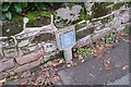
3
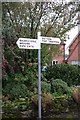
Chapel Lane
You can see the location of Image The valve itself is on the other side of the road, by the kerb near the lamppost
Image: © Bob Harvey
Taken: 8 Oct 2019
0.05 miles
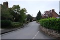
4
Service valve sign
The valve is on the other side of the road, see Image
Image: © Bob Harvey
Taken: 8 Oct 2019
0.05 miles
6
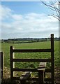
Stile into the fields, Norton in Hales
Looking across fields towards the Arbour Farm.
Image: © Simon Huguet
Taken: 21 Feb 2009
0.06 miles
7
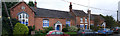
The primary school, Norton in Hales
This is the original Victorian building. A more modern one is not visible from the road.
Image: © Bob Harvey
Taken: 8 Oct 2019
0.07 miles
9
Main Road, Norton in Hales
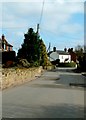
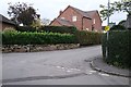
Looking south west.
Image: © JThomas
Taken: 1 Jun 2019
0.08 miles