IMAGES TAKEN NEAR TO
Wharmadine Lane, MARKET DRAYTON, TF9 4NF
Introduction
This page details the photographs taken nearby to Wharmadine Lane, TF9 4NF by members of the Geograph project.
The Geograph project started in 2005 with the aim of publishing, organising and preserving representative images for every square kilometre of Great Britain, Ireland and the Isle of Man.

There are currently over 7.5m images from over14,400 individuals and you can help contribute to the project by visiting https://www.geograph.org.uk
Image Map (Loading...)


Getting Data...Please wait
Leaflet Map data © OpenStreetMap
Images are licensed for reuse under creativecommons.org/licenses/by-sa/2.0
Notes
- Clicking on the map will re-center to the selected point.
- The higher the marker number, the further away the image location is from the centre of the postcode.
Image Listing (3 Images Found)
Images are licensed for reuse under creativecommons.org/licenses/by-sa/2.0
Image
Details
Distance
1
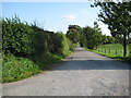
Drive to Fields Farm
Farm drive off Wharmadine Lane
Image: © Peter Fleming
Taken: 11 Sep 2007
0.10 miles
2
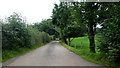
Drive to Fields Farm, 2016
Nine years since the First Geograph for this square and nothing else in between; I come along and take a shot of the same scene. See Image
Image: © Jonathan Billinger
Taken: 6 Sep 2016
0.12 miles
3
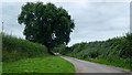
Wharmadine Lane
Looking south-west, towards Ashley, by the entrance to Fields Farm.
A fine specimen ash tree.
Image: © Jonathan Billinger
Taken: 6 Sep 2016
0.14 miles